Identification of Changes in Extent and Density of Mangrove Vegetation Cover in Ambon Bay Using PlanetScope Satellite Imagery
Abstract
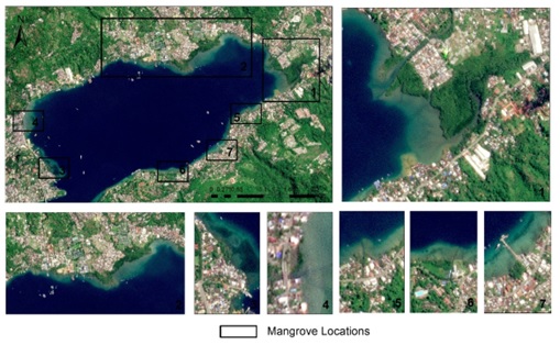
Mangrove forests represent a coastal ecosystem located in the transitional zone between land and sea. This ecosystem thrives in the intertidal zone, where seawater naturally rises and falls daily. Mangrove forests face serious degradation threats due to development activities and land conversion, including in Ambon Bay. This study utilized high-resolution PlanetScope imagery at 3 m resolution and the NDVI algorithm to analyze mangrove vegetation extent and density. The results indicate a consistent decline in mangrove vegetation area in Ambon Bay, from 55.79 ha in 2016 to 53.75 ha in 2020 and further to 49.87 ha in 2026, representing a total loss of 5.92 ha (10.6%) over the decade. NDVI analysis from 3 m PlanetScope imagery reveals the complex dynamics of mangrove density in Ambon Bay, with low-density area increasing from 3.05 ha (2016) to 4.23 ha (2020) and 5.51 ha (2026), medium-density area fluctuating from 11.15 ha (2016) to 10.38 ha (2020) and then 12.81 ha (2026), while high-density area experienced progressive degradation from 39.00 ha in 2016 to 37.16 ha (2020) and 29.87 ha in 2026. The Ambon City regional government must establish strict mangrove conservation zones in Ambon Bay through comprehensive revisions to the Regional Spatial Plan, prohibiting mangrove land conversion for unsustainable industrial or residential development, and promoting community participation through economic incentives such as mangrove ecotourism and sustainable fisheries, which will strengthen socio-ecological resilience, where local residents are trained as area managers to periodically monitor vegetation density.
Downloads
References
Alimudi, S., Ohiwal, M., Kaliky, N. A. P., Nurlete, H., Kaliky, K., Irwan, N., & Waleulu, M. (2023). Deteksi Perubahan luasan mangrove Teluk Ambon dalam Menggunakan citra satelit multitemporal. Jurnal Laot Ilmu Kelautan, 5(2), 193–203. https://doi.org/https://doi.org/10.35308/jlik.v5i2.8436
Baloloy, A., Blanco, A., Candido, C., Argamosa, R., Dumalag, J., Lee Carandang DImapilis, L., & Paringit, E. (2018). Estimation of mangrove forest aboveground biomass using multispectral bands, vegetation indices and biophysical variables derived from optical satellite imageries: Rapideye, Planetscope and Sentinel-2. ISPRS Annals of the Photogrammetry, Remote Sensing and Spatial Information Sciences, 4(3), 29–36. https://doi.org/10.5194/isprs-annals-IV-3-29-2018
Basyuni, M., Mubaraq, A., Aznawi, A. A., Sari, S. P. M., Ayu, S. M., Wahyuni, T., Siregar, E. S., Slamet, B., Sumarga, E., Larekeng, S. H., Agustina, N. A., Gonzales, R. C., Leopardas, V. E., Ali, H. M., & Amir, A. A. (2025). Edible and medicinal uses of mangroves in Indonesia with a systematic review on blue food potential and health benefits. Discover Sustainability, 6(1), 1140. https://doi.org/10.1007/s43621-025-01967-3
Belseran, C., & Waas, E. (2022). Hutan Mangrove Teluk Ambon Memprihatinkan. MONGABAY. https://mongabay.co.id/2022/08/07/hutan-mangrove-teluk-ambon-memprihatinkan/
Herman, W. (2025). Pemkot Ambon tanam 75 anakan mangrove tingkatkan perlindungan pesisir. ANTARA News. https://ambon.antaranews.com/berita/288565/pemkot-ambon-tanam-75-anakan-mangrove-tingkatkan-perlindungan-pesisir
Kolengsusu, A. K., Sihasale, D. A., & Riry, J. (2024). The Role of the community in mangrove conservation in the sea waters of Poka Village, Teluk Ambon District, Ambon City. Jurnal Pendidikan Geografi Unpatti, 3(1), 23–33. https://doi.org/10.30598/jpguvol3iss1pp23-33
Latumahina, F. S., Susilawati, S., Antonius, A., & Tewoloipaky, W. (2024). Mangrove diversity as an indicator of ecosystem health on Ambon Island, Indonesia. Agro Bali: Agricultural Journal, 7(2), 295–306. https://doi.org/https://doi.org/10.37637/ab.v7i2.1637
Liu, Y., Liu, K., Cao, J., Wen, X., Zhu, Y., & Wang, X. (2026). Exploring fine-scale mangrove phenology along the coast of China using time series SuperDove images. Ocean & Coastal Management, 273, 108059. https://doi.org/https://doi.org/10.1016/j.ocecoaman.2025.108059
Mahardhika, S. A., & Kamal, M. (2020). Estimation of Fractional Canopy Cover of Bedul Mangrove Forest Using PlanetScope Imagery. https://doi.org/10.1109/ICST50505.2020.9732791
McNulty, V. P., Perez, D., Simpson, S., Beneby, J., Joseph-Witzig, A., Jones, L., Smart, L., Moyer, R. P., Gibson, S., Musgrove, M., Cattafesta, C., & Schill, S. R. (2025). The blue carbon explorer: a Google Earth Engine tool for mangrove restoration. Frontiers in Environmental Science, 13. https://doi.org/10.3389/fenvs.2025.1641301
Moh Ponting. (2023). Mangrove Teluk Ambon berkurang 10 hektare dalam dua dekade terakhir, begini penyebabnya. ANTARA News. https://ambon.antaranews.com/berita/153075/mangrove-teluk-ambon-berkurang-10-hektare-dalam-dua-dekade-terakhir-begini-penyebabnya
Pietersz, J. H., Pribadi, R., Pentury, R., & Ario, R. (2024). Estimasi tutupan kanopi berdasarkan NDVI dan kondisi tutupan tajuk pada ekosistem mangrove Negeri Passo, Teluk Ambon Dalam. Jurnal Kelautan Tropis, 27(2), 197–208. https://doi.org/https://doi.org/10.14710/jkt.v27i2.22090
Purnamasari, E., Kamal, M., & Wicaksono, P. (2021). Comparison of vegetation indices for estimating above-ground mangrove carbon stocks using PlanetScope image. Regional Studies in Marine Science, 44. https://doi.org/10.1016/j.rsma.2021.101730
Rachman, H. A., & Hanifa, S. N. (2024). Spatio-temporal NDVI changes of mangrove forest in West Bangkalan using high resolution imagery. E3S Web of Conferences, 499. https://doi.org/10.1051/e3sconf/202449901032
Rifai, A., Halim, Rakuasa, H., Tade, F., Purnama, A., Jufriansah, A., & Khusnani, A. (2025). Spatial analysis of vegetation index in Ambon City Center Area, Indonesia using Sentinel-2 Satellite Imagery in Google Earth Engine. Frontiers in Sustainable Science and Technology, 2(1), 32–40. https://doi.org/10.69930/fsst.v2i1.365
Rihulay, T. D., & Papilaya, F. S. (2022). Analisa perubahan luas tutupan lahan mangrove di Teluk Ambon Dalam menggunakan OBIA. Journal of Information System, Graphics, Hospitality and Technology, 4(1), 7–12.
Rivera-Solís, J., Quesada-Roman, A., & Castillero, R. G. (2025). Land use and land cover analysis with special reference to mangrove dynamics for sustainable use in the Rosario River sub-basin, Pixvae, Panama. Journal of South American Earth Sciences, 157. https://doi.org/10.1016/j.jsames.2025.105464
Rondon, M., Ewane, E. B., Abdullah, M. M., Watt, M. S., Blanton, A., Abulibdeh, A., Burt, J. A., Rogers, K., Ali, T., Reef, R., Mohtar, R., Sidik, F., Fahrenberg, M., de Miguel, S., Pabodha Galgamuwa, G. A., Yassine, Y. A. R., Arachchige, P. S. P., Velasquez-Camacho, L. F., Al Awadhi, T., Mohan, M. (2023). Remote sensing-based assessment of mangrove ecosystems in the Gulf Cooperation Council countries: a systematic review. Frontiers in Marine Science, 10. https://doi.org/10.3389/fmars.2023.1241928
Sahitya, A. F., Kamal, M., & Farda, N. M. (2026). Assessing the performance of random forest and deep forest algorithms for Mangrove canopy cover mapping using PlanetScope SuperDove imagery. Remote Sensing Applications: Society and Environment, 41, 101875. https://doi.org/https://doi.org/10.1016/j.rsase.2026.101875
Salakory, M., Rakuasa, H. (2022). Modeling of Cellular Automata Markov Chain for predicting the carrying capacity of Ambon City. Jurnal Pengelolaan Sumberdaya Alam Dan Lingkungan (JPSL), 12(2), 372–387. https://doi.org/https://doi.org/10.29244/jpsl.12.2.372-387
Salakory, M.,. & Pinoa, W.S. (2019). Factors analysis of mangrove forest ecosystem conservation strategic In Baguala Ambon Bay District, Indonesia. International Journal of Scientific and Research Publications (IJSRP), 9(3), 604–407. https://doi.org/http://dx.doi.org/10.29322/IJSRP.9.03.2019.p8783
Sofue, Y., Quevedo, J. M. D., Lukman, K. M., & Kohsaka, R. (2025). Identifying changes in mangrove landscapes in the Philippines and Indonesia using remote sensing and community perceptions: Towards ecosystem services management. Regional Studies in Marine Science, 82, 104023. https://doi.org/https://doi.org/10.1016/j.rsma.2025.104023
Suyadi. (2012). Satu dekade kondisi hutan mangrove di Teluk Ambon, Maluku. Jurnal Biologi Indonesia, 8(1), 197–203.
Tapilatu, Y., & Pelasula, D. (2012). Biota penempel yang berasosiasi dengan mangrove di Teluk Ambon Bagian Dalam. Jurnal Ilmu Dan Teknologi Kelautan Tropis, 4(2), 267–279.
Wei, S., Zhang, H., & Ling, J. (2025). A review of mangrove degradation assessment using remote sensing: advances, challenges, and opportunities. GIScience & Remote Sensing, 62(1), 2491920. https://doi.org/10.1080/15481603.2025.2491920
Zita M. (2021). LIPI: Teluk Ambon bagian dalam terancam dangkal akibat sedimentasi. ANTARA News. https://www.antaranews.com/berita/2201890/lipi-teluk-ambon-bagian-dalam-terancam-dangkal-akibat-sedimentasi
Copyright (c) 2026 Heinrich Rakuasa, Stewart Pertuack, Ahmad Rifai, Halim Halim

This work is licensed under a Creative Commons Attribution-NonCommercial-ShareAlike 4.0 International License.
Authors who publish with BIOEDUPAT: Pattimura Journal of Biology and Learning agree to the following terms:
- Authors retain copyright and grant the journal right of first publication with the work simultaneously licensed under a Creative Commons Attribution License (CC BY-NC-SA 4.0) that allows others to share the work with an acknowledgment of the work's authorship and initial publication in this journal.
- Authors are able to enter into separate, additional contractual arrangements for the non-exclusive distribution of the journal's published version of the work (e.g., post it to an institutional repository or publish it in a book), with an acknowledgment of its initial publication in this journal.
- Authors are permitted and encouraged to post their work online (e.g., in institutional repositories or on their website) prior to and during the submission process, as it can lead to productive exchanges, as well as earlier and greater citation of published work.













 This work is licensed under a